Research
Our research is focused within the hydrological sciences, but includes ecology and often has sociopolitical implications. Our projects have taken us from Alaska through Latin America. Some of our major research themes are briefly described below. For more detail, refer to the links provided and to the descriptions in the "people" tab
Project Spotlight
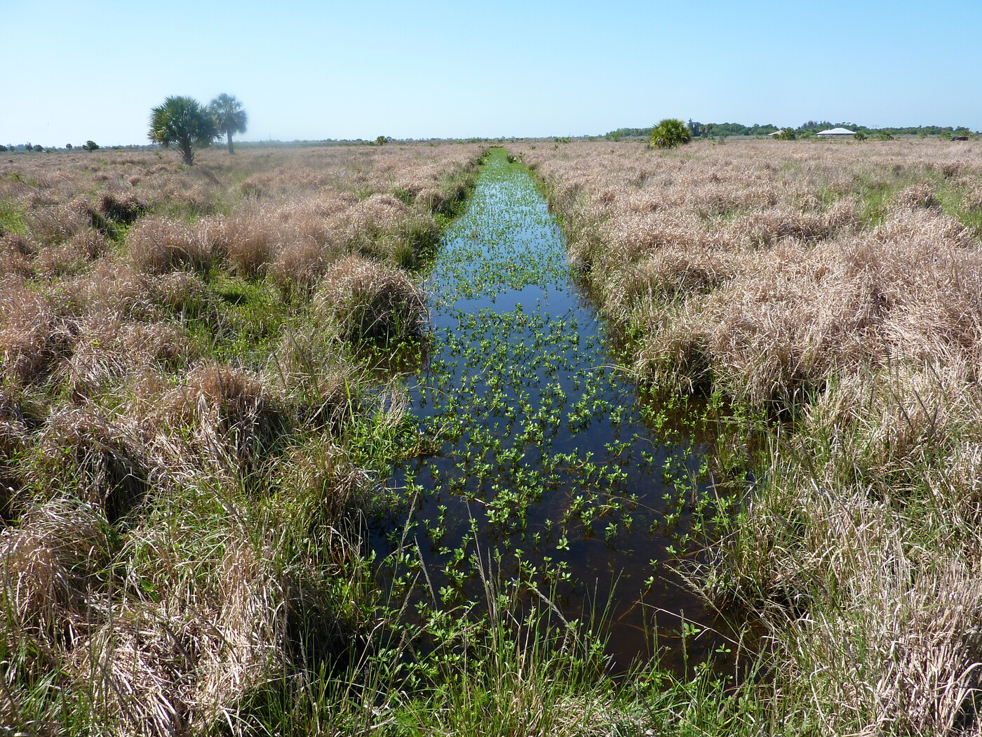
Expansion-Contraction Spatial and Temporal Variability in Connectivity in Stream-Wetland Flow Networks
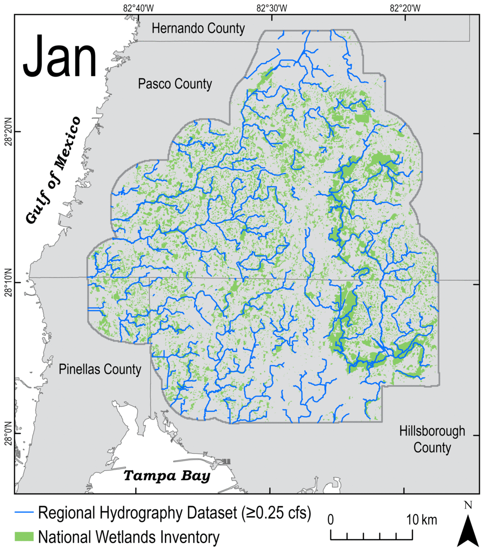
Wetland-stream flow networks expand and contract through storms and seasons, driven by interactions between climate, geology, and topography. This expansion and contraction is a fundamental property of wetland-stream flow networks, and plays a crucial role in how mass, energy, and organisms are transferred within storms and through seasons at the watershed scale. The flood-pulse concept was previously defined in terms of exchanges between channels and floodplains. In this project, we visualize and quantify a variant of that concept defined instead in terms of the expansion and contraction of wetland-stream flow networks, which could perhaps be more accurately referred to as the flow-pulse concept. The gif you are viewing illustrates the expansion and contraction that occurs annually in our study area within the Tampa Bay Watershed in west-central Florida.
Research Themes
Climatic, Geologic, and Topographic Control on the Structure and Function of Wetlands
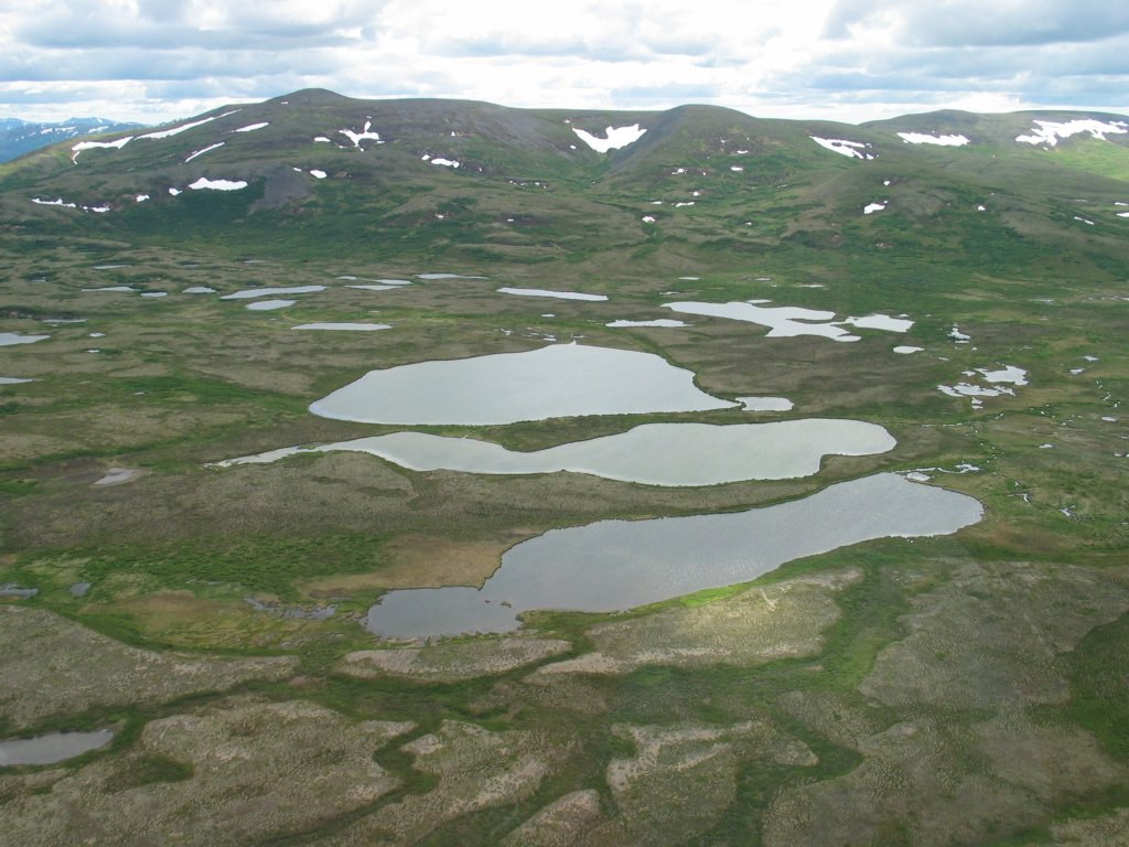
Hydrological processes are controlled by complex interactions between climate, geology, and topography. These three drivers operate at different scales, but together control the location, structure, and function of wetlands. Our work links hydrology, geochemistry, shallow-earth geophysics, numerical modeling, and more, seeking to better understand these controls in wetlands throughout North America, from sandhill wetlands in Florida, to vernal pools in California, to small ponds in Alaska.
- Article - Using remote sensing and machine learning to locate groundwater discharge to salmon-bearing streams
- Article - The peculiar hydrology of West-Central Florida sandhill wetlands, ponds, and lakes, Part 1: Physical & chemical evidence of connectivity to a regional water-supply aquifer
Balancing Limited Water Resources Between Human and Natural Users
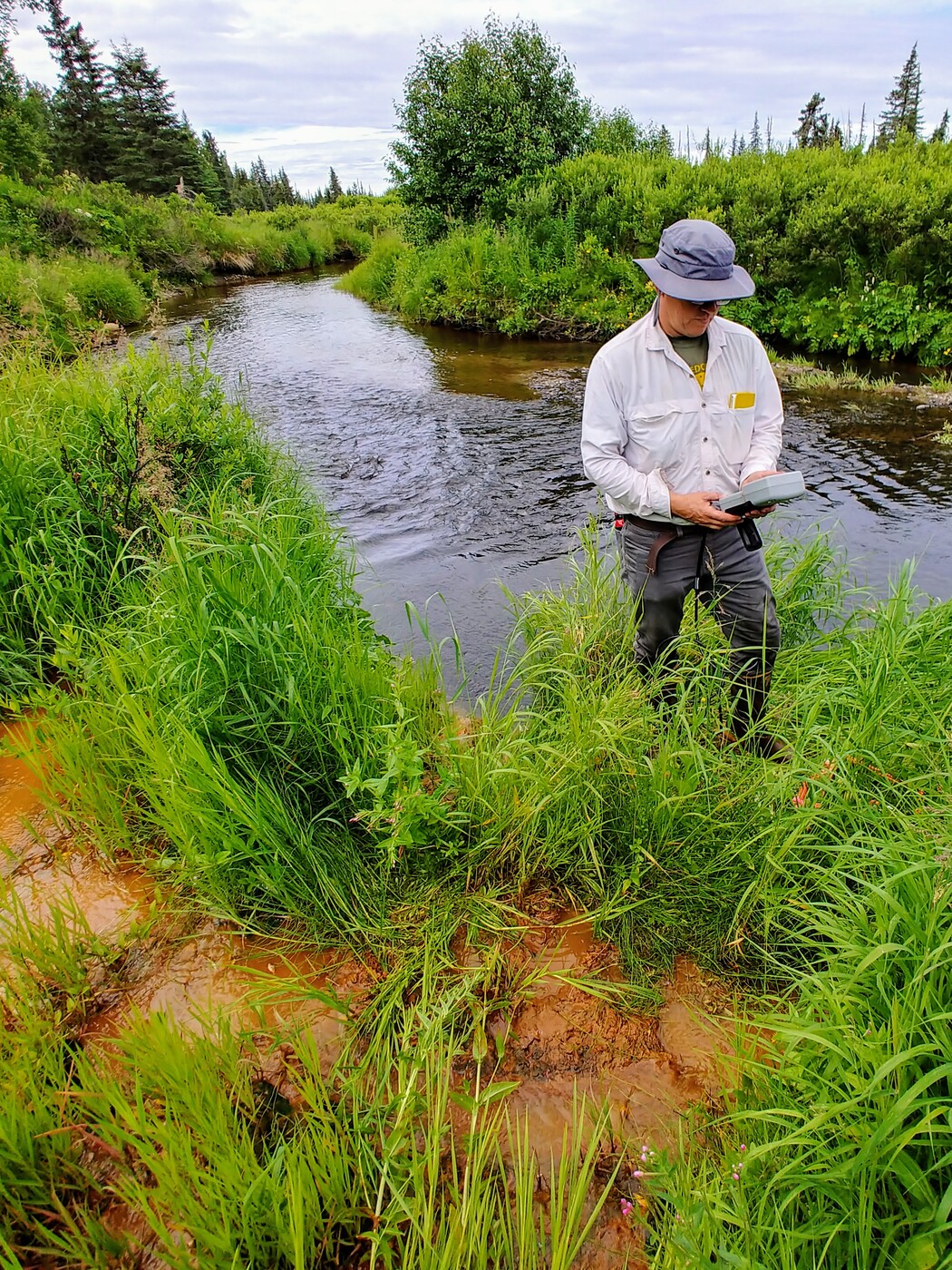
Water connects landscapes from ridge-to-reef, supporting both human and natural users. In the Kenai Peninsula Lowlands in south-central Alaska, groundwater plays a disproportionately important role. It is the primary source of domestic, commercial, and industrial water; simultaneously, it supports stream flow, modulates stream temperature, and provides nutrient subsidies in salmon-bearing streams. Without groundwater, there would be few people or salmon. Though crucial to both human and natural users, it is also in limited supply, being stored and transmitted in thin, discontinuous aquifers. Our work here is transdisciplinary, linking hydrology, biogeochemistry, ecology, social science, geospatial analysis, and modeling. We work in collaboration with the Kachemak Bay National Research Reserve and alongside our key stakeholders, creating a shared knowledge that enables sound local decision-making.
- Website Link - Promoting Resilient Groundwater Resources and Holistic Watershed Management in the Southern Kenai Lowlands
- Article - Linking landscape attributes to salmon and decision-making in the southern Kenai Lowlands, Alaska, USA.
- Seminar - Groundwater Subsidies to Salmonid Streams: A Decade+ of Collaborative Science and Outcomes in Alaska
- Article - Using remote sensing and machine learning to locate groundwater discharge to salmon-bearing streams.
- Article - Mapping groundwater recharge potential in high latitude landscapes using public data, remote sensing, and analytic hierarchy process
Reorganization of the Waterscape by Wetland Loss and Drainage Network Extension
The conterminous United States lost more than half of its wetland area between European settlement and the late 1980s. Recently, the trend has changed nationally, with wetland area in the conterminous United States remaining approximately constant in recent years. However, the trend has not changed in coastal watersheds on the Atlantic and Gulf of Mexico coasts, where wetland area continues to decrease. Net gains in wetland area, where they have occurred, can be largely attributed to both created or restored wetlands and other waterbodies (e.g., stormwater ponds). Concomitantly, ditching and draining has extended the natural drainage network and increased drainage efficiency. The subsequent rearrangement of the waterscape has been done incrementally in a series of one-off decisions, with no coherent, watershed-wide guidance or plan. This represents a large-scale shift in ecosystem functions, and the ecosystem services they provide, a massive experiment with no controls and unknown and/or unconsidered consequences.
- Article - Forensic wetland and deepwater habitat mapping for setting pre-development conditions
- Article - Reorganizing the waterscape: Asymmetric loss of wetlands and gain of artifical water features in a mixed-use watershed
- Article - Using net wetland loss, current wetland condition, and planned future watershed condition for wetland conservation planning and prioritization, Tampa Bay Watershed, Florida
H2O: Hydrologic Connectivity from Headwaters to Oceans

Hydrological flowpaths connect landscapes in four dimensions—longitudinally, laterally, vertically, and through time. This four-dimensional hydrological connectivity, operating at local to landscape scales, is a basic tenet of freshwater ecology. Hydrological flowpaths are dynamic, expanding and contracting through seasons and storms, which results in headwater wetlands and streams being connected to downstream wetlands and waterbodies along a continuum controlled by watershed wetness, at various times and places disconnected, connected by slow groundwater flows, or connected by surface-water flows. Especially when and where the latter occurs, headwater wetlands andstreams can be fully integrated into the surface-water flow network and serve as significant sources of water and water-borne materials for downgradient wetlands and waterbodies.
- Article - National hydrologic connectivity classification links wetlands with stream water quality.
- Article - Using remote sensing and machine learning to locate groundwater discharge to salmon-bearing streams
- Article - Connecting the dots: hydrologic connectivity between wetlands and other wetlands and waterbodies
The Roles Sciences Play in Informing Environmental Policy, Practice, and Protection

Science plays a crucial role in informing environmental policy, practice, and protection. Science is certainly not the only consideration, but it delineates the universe within which a broader dialog can occur, one in which the additional social, economic, and political considerations can be weighed. We have extensive experience in consensus building at the intersection of science and policy, especially in wetland regulatory programs, including past and ongoing work providing the scientific justification underlying the federal definition of “waters of the US” subject to regulation under the Clean Water Act. This experience is expanding while M. Rains serves as the Chief Science Officer for the State of Florida, a post in which he is charged with ensuring that science underlies sound environmental policy and protection. This includes coordinating and prioritizing scientific data, research, and analysis to ensure alignment with current and emerging environmental concerns; identifying and setting priorities for key research initiatives; reviewing the allocation of funding for all related research projects; collaborating with the scientific community; and cultivating and maintaining relationships with internal and external stakeholders. During his first term as Chief Science Officer, his primary foci have been improving water quality and reducing the severity of harmful algal blooms, building a statewide database that can support flood resilience planning and projects, and developing the data and analytics strategy necessary to support these and other statewide environmental initiatives.
- Article - Visioning the Future: Scenarios Modeling of the Florida Coastal Everglades
- Article - Linking Landscape Attributes to Salmon and Decision-Making in the Southern Kenai Lowlands, Alaska, USA
- Article - Enhancing Protections for Vulnerable Waters
Controls on Water Quality and Associated Harmful Algal Blooms

Water-quality degradation is a “wicked problem,” a challenge that is difficult to overcome because of incomplete or contradictory understanding, the number of factors involved, the large economic burden of the possible solutions, and the interconnected nature of terrestrial and aquatic environments, which are commonly studied separately. The problem is rooted in how water and contaminants are routed from “ridge-to-reef’, with myriad natural and anthropogenic forcings and feedbacks. These projects are designed to address these complex matters, bringing together scientific expertise and stakeholder partners under a set of common thematic questions.
- Report - Pilot Scale Development of a Septic-to-Sewer Conversion Prioritization Tool Using Analytical Hierarchy Process Phase II: Landscape Vulnerability.
- Article - Modeling temporal and spatial variations of biogeochemical processes in a large subtropical lake: assessing alternative solutions to algal blooms in Lake Okeechobee, Florida.
- Resource - Protecting Florida Together
Nutrient Cycling Through Soils, Water, and Roots
It is surprising how little we know about the world below our feet- the roots and soils and nutrient dynamics thatsustain the plants and other entities we depend upon. We are investigating the transfer of nutrients from decomposing matter, through fungal hyphae, roots, soil, and groundwater. These transformations aid in the removal of N from our waterways of C from the atmosphere yet occur in a complex matrix of soil and a micro-atmosphere that can be very different than our own.
- Article - Nitrogen Subsidies from Hillslope Alder Stands to Streamside Wetlands and Headwater Streams, Kenai Peninsula, Alaska
- Article - Saltwater Intrusion as Potential Driver of Phosphorus Release from Limestone Bedrock in a Coastal Aquifer
- Article - Total and mobile fractions of carbon and nitrogen in surface soils across a mangrove salt marsh ecotone.
- Article - Epiphytic and terrestrial mycorrhizas in a lower montane Costa Rican cloud forest
- Article - Shifting ground: Landscape-scale modeling of biogeochemical processes under climate change in the Florida Everglades