1848 Hurricane
Sept. 25th of 1848
http://oceanweatherservices.com/blog1/2011/09/21/the-great-tampa-gale-of-1848/
Possible Tracks for the 1848 Tampa Hurricane. Image courtesy
of James B. Elsner, Department of Geography Florida State University: 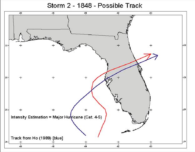
Winds- estimated
maximum winds of 101-135 mph
(http://www.wunderground.com/blog/fredwx/great-1848-tampa-hurricane)
Surge
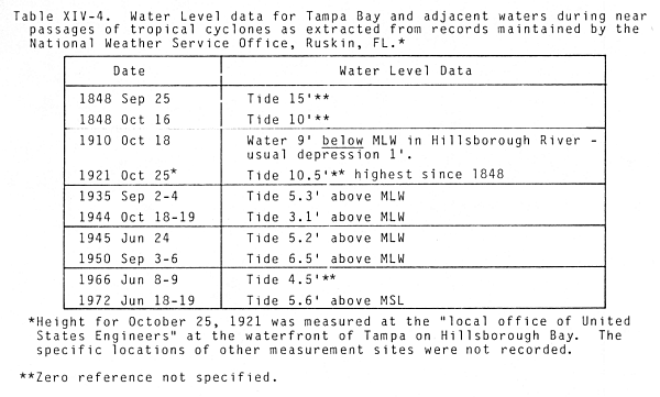
heights or water levels- 15 feet above low water
Damage
descriptions-
http://www.wunderground.com/blog/fredwx/great-1848-tampa-hurricane
·
estimated maximum winds of 101-135 mph moved NNW just off the
west coast of Florida causing considerable damage at Charlotte Harbor as it
passed to the west. As the storm moved northward along Florida’s west coast it appears to have turned to the NE and
then ENE making landfall near Clearwater during the early afternoon of Sept.
25, 1848
·
all the
wharves and most public building at the fort were destroyed and that flooding
was exceptionally great but no lives were lost at Ft. Brooke. The post surgeon
reported that the tide rose 15 ft above low water
and the �water rose
very fast between 1000 and 1400�. It was
also reported that all of the vessels in the port were driven up the river and
destroyed by the high winds and storm surge.
·
1848 is that a second hurricane hit Tampa one month
later in October causing a 10 ft tide in the Bay
·
In 1848 Tampa was a small
village of fewer than 200 people
·
An interesting legend regarding the 1848 Hurricane is
that it created a new pass through a barrier island which was discovered by a
reformed pirate named John Levique. Today the pass is known as "John's
Pass"
http://oceanweatherservices.com/blog1/2011/09/21/the-great-tampa-gale-of-1848/
·
Solid Cat. 3 storm
·
making landfall near Clearwater
·
Other accounts stated that great waves covered most of
the islands within the bay and that the garrison at Fort Brooke was almost
completely inundated by water and waves pounded and destroyed the barracks,
horse shed and other structures and only the tops of the trees could be seen. The recently opened lighthouse at Edmont Key
was badly damaged and had to be rebuilt.
·
Every building on the bay and river was destroyed
except for the Palmer Hotel which was badly damaged. At the Garrison the church
on the beach, the soldier’s barracks, the Indian agent’s office and the Ferris
residence, store and warehouse were wrecked.
According to Juliet Axtell, the wife of the Army Chaplain, “there were
not more than four or five buildings left standing” and she concluded in a
letter that “Tampa was no more.
·
Second hurricane visited the
Florida West Coast on October 11-12th.
In Tampa this storm was not as intense as the earlier one; however, it did
cause a storm surge to about 10ft in Tampa Bay
http://www.theledger.com/article/20120529/COLUMNISTS0404/205295000?p=2&tc=pg
·
Amidst a torrential downpour and whipped by hurricane
winds, monstrous waves crashed ashore through most of the day," Brown
wrote. "By noon water levels had risen by 15 feet,
and there they stayed for hours."
·
Damage was reported as far inland as today's Sebring
and as far south as Charlotte Harbor. But none suffered more than Tampa, which
saw Fort Brooke destroyed as well as most privately owned buildings.
http://majikphil.blogspot.com/2012/08/tampas-hurricane-history.html#!/2012/08/tampas-hurricane-history.html
·
Wade weathered the storm in Fort Brooke, in what is
now downtown Tampa
·
the pressure and storm surge is more like a strong
category 3 or even a category 4 hurricane
·
Only five buildings were left standing in Tampa, and
all were damaged. Fort Brooke was
destroyed
·
The “Gulf met the Bay” in Pinellas which was cut in
half by the storm surge. Waters from
Tampa Bay flowed back through the middle of Pinellas County to reach the Gulf
of Mexico. Allen’s Creek was a half a
mile wide at its mouth.
Other hurricane Data
·
A young woman who endured the storm insisted that
"at one time it rose five feet in fifteen minutes.
http://www.nrlmry.navy.mil/port_studies/tr8203nc/tampa/text/sect3.htm
http://www.floridamemory.com/exhibits/timeline/
|
1830 |
|
First Florida census: population 34,730 |
http://www.sarasotahistoryalive.com/stories/journals-of-yesteryear/southwest-florida-history-littered-with-hurricanes/
·
major storm hit the Tampa Bay area and destroyed Fort
Brooke